MassDEP - Bureau of Waste Site Cleanup
Phase 1 Site Assessment Map: 500 feet & 0.5 Mile Radii
- Site Information:
- NAD83 UTM Meters:
Phase 1 Site Assessment Map: 500 feet & 0.5 Mile Radii
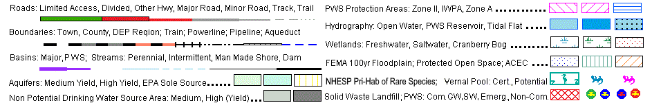
The information shown is the best available at the date of printing. However, it may be incomplete.
The responsible party and LSP are ultimately responsible for ascertaining the true conditions surrounding the site. Metadata for data layers shown on this map can be found at:
https://www.mass.gov/orgs/massgis-bureau-of-geographic-information.
 |

1.) Enter Site Information, to be displayed in the map header. Then click "Go to Map" button.
2.) Use the tools to navigate the aerial map and located the site with the  tool to generate the MCP map.
3.) Click the "Print" button to submit the map to your printer.
|
|
The purpose of this tool is to allow a Potentially Responsible Party (PRP) or a Licensed Site Professional (LSP) to generate a Phase 1 Site Assessment Map that is suitable for printing on a standard letter ( 7.5” x 11” ) sized portrait page. |
|
|
The name, address, town and RTN information provided will be displayed at the top of the map. Address and or town information is also used to zoom the map to the general area of the site. Once the map opens at this initial extent you can use the Map Tools outlined below to navigate the map, locate a site and generate an MCP NRS Map. |
|
|
Note: A red outline surrounding the tool icon |
| Select the Zoom In tool to zoom the map in to a larger scale. You may either click on a single point on the map to zoom in one zoom level or zoom to a general area by clicking and dragging the cursor to create a selection box around your area of interest. Since the map uses preset zoom levels the resulting extent will be the closest preset zoom level to your chosen area. The Zoom In tool automatically recenters the map display on the selected point or the center of the selection box. | |
| Click the Zoom Out tool to zoom the map out one zoom level. | |
| Select the Pan Map tool, then click and drag the map to move around (pan) on the map in any direction. | |
| Click the Full Extent tool to zoom the map out to the maximum extent. This will return the map display to the full extent of the State of Massachusetts. | |
| Use the Create MCP Map tool to locate a site and create an MCP NRS Map with 500 ft and .5 mile buffers around the site. Once a site is located the MCP Layers are loaded and the map is locked down for printing. If you wish to change the location of your site you will need to create a new map. |
|
|
The browser's Print function can be used to print this map. You may also use the browser's Print Preview function to view the map prior to printing. This map is formatted to output on a single, standard letter ( 7.5” x 11” ) sized, portrait page. Make sure the browser's print page orientation is set for portrait. If the map prints on more than one page you may need to adjust other page setup options, such as reducing margins or turning off headers and footers. |
If you require further assistance using this tool, please email questions to the MassDEP
Bureau of Waste Site Cleanup
bwsc.edep@massmail.state.ma.us
 indicates that the tool is active. Only one tool can be active at a time.